
Calling for a review of the disaster prevention map in Hirosaki City
Following the debris flow disaster that occurred in Atami City, Shizuoka Prefecture on July 3, the Hirosaki City Disaster Prevention Division is calling for a review of the hazard map.
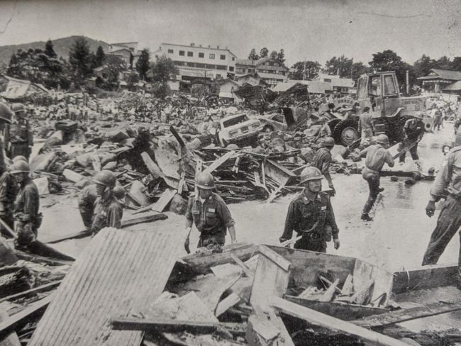
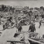
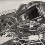
In Hirosaki, torrential rain fell before dawn on August 6, 1975, and debris flows occurred in 6 mountain streams in the former Iwaki-cho Hyakuzawa district. 22 people were killed, 31 were seriously injured, and 22 houses were completely destroyed or washed away. Above all, the flow path from the east side of Iwakiyama Shrine to the vicinity of Hyakuzawa downstream was swept away by houses, and the disaster area extended to paddy fields 1 km downstream from the prefectural road.
Tomoyuki Nakamura of the Hirosaki City Disaster Prevention Division says, "I don't know when a disaster will occur. I want you to check the hazard map where you should escape in peacetime, not after it happens."
Hirosaki City publishes "Hirosaki City Disaster Prevention Map Safe and Secure Town Development". In August of last year, it was revised for the first time in 11 years. In particular, since "My Timeline" has the consciousness of "protecting one's own life by oneself", an index is shown so that one's own behavior at the time of a disaster can be confirmed in the evacuation behavior judgment flow.
Mr. Nakamura said, "In the event of a disaster, you do not always have to go to an evacuation site. If you live on the upper floors of an apartment, you can stay at home to ensure safety. Evacuate to a safe relative or acquaintance's house. I want you to be aware that the action of protecting yourself is the evacuation. "
The "Hirosaki City Disaster Prevention Map" is installed at administrative facilities such as the city hall, and is also available on the website.